
Laminated map
Suggestions for Laminated map
Laminated city map Laminated road map Laminated wall map Laminated atlas map Laminated world map Folded laminated map Laminated poster map Laminated school map Laminated street map Laminated travel map Laminated country map Laminated regional map Laminated classroom map Laminated continent map Laminated map with index Educational laminated map Laminated city street map Framed laminated world map Laminated country atlas map Laminated map for classroom Laminated physical atlas map Laminated physical world map Laminated regional atlas map Laminated political atlas map Laminated political world map Rand McNally world map laminated National Geographic world map laminated

Maps International (9781903030578 / MILWLD120)

Ordnance Survey (9780319246887)

Explore Scotland’s rugged peaks with the Ordnance Survey OS Explorer Active Map 392 – Ben Nevis, Fort William, the Mamores, Grey Corries, Kinlochleven & Spean Bridge. Waterproof, detailed terrain for hikers and adventurers.

Ordnance Survey (9780319242650) - Category: Walking, hiking, trekking - Dimensions: (H) 243mm, (W) 136mm, (D) 15mm - Country of publication: UNITED KINGDOM - Edition: May 2015 ed - Weight: 132 grams - Ordnance Survey

Ordnance Survey (9780319242599) - Category: Walking, hiking, trekking - Dimensions: (H) 244mm, (W) 136mm, (D) 15mm - Country of publication: UNITED KINGDOM - Edition: 2015 ed - Weight: 132 grams - Ordnance Survey | OS Explorer

Michelin (9782061010716) - Country of publication: FRANCE - Dimensions: 250 x 113 x 5 mm - Edition: 2017 - ISBN: 9782061010716 - Number of pages: 1 - Michelin Editions des Voyages - In Print - Weight: 610 grams | Wall map

The Genuine Company Limited (9781905502226) - World atlases / world maps - The Genuine Company Limited - ISBN: 9781905502226

(9783829767774) - World atlases / world maps - MAIRDUMONT GmbH & Co. KG - ISBN: 9783829767774 - Pages: 1 pages

(9782067229945) | Streetwise Tokyo Map, Map of Tokyo

Maps International (9781904892052 / MILAUSAS)


Ordnance Survey (9780319148389) - World atlases / world maps - Ordnance Survey - ISBN: 9780319148389

Discover essential insights with the Ordnance Survey British Isles Communication Wall Map. This laminated guide provides detailed views of transportation networks across the region, perfect for planners and enthusiasts alike.

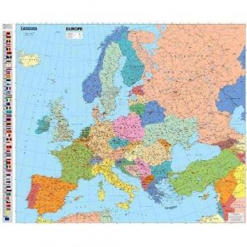
Explore Europe in stunning detail with the Ordnance Survey OS Lambert Projection wall map—laminated for durability and precision. Ideal for planners, educators, or travel enthusiasts seeking a clear, comprehensive view of the continent.

Ordnance Survey (9780319148426)

Ordnance Survey (9780319148419)

Magnetic world map board, 120x90 cm, laminated and lacquered for durable display. Features a smooth magnetic surface to attach pins, notes, or stickers, ideal for offices, classrooms, or travel planners.

(9780721709383)

(9780721711614) - Dimensions: 54.0cm x 7.0cm - ISBN: 9780721711614 - Publish date: 18/03/2011 - Schofield & Sims Ltd | Stone Age

Borch GmbH (9783866093621 / 9783866093621)

Lamknated educational wall map - Shows physical and political features - Shows animals and sea creatures of the world - Shows world flags - Shows over 45o geographical, social and cultural facts of the world
Discover the politics of Europe with Michelin's detailed and encapsulated wall map, available in stores now.

Explore Copenhagen like a local with the laminated Streetwise Map – a detailed city center guide featuring Michelin-rated streets, landmarks, and insider tips for effortless navigation.


Filters